The Missouri River Breaks A Land of Visionary Enchantment
Ken Walcheck | Tuesday Aug. 1st, 2023
To Meriwether Lewis, Esquire…. “The object of your mission is to explore the Missouri river, and such principle streams of it, as, by its course and communication with the waters of the Pacific ocean, whether the Columbia, Oregan (sic), Colorado, or any other river, may offer the most direct and practicable water-communication across the continent for the purposes of commerce.”
Lewis and William Clark fulfilled this part of President Jefferson’s directive in a most exemplary fashion, far beyond his wildest expectations.
The Missouri, as documented by Meriwether Lewis, who possessed a degree of literary flair, was a wild river then, a sinuous giant that worked incessantly to dissipate its unlimited supply of energy. It honed new channels, destroying as well as building and reshaping islands into myriad geometric shapes. It was a river that scoured deep holes and sealed off quiet, shallow pools and C-shaped oxbows, a complex river system constantly changed by nature’s age-old rhythms, while being held in delicate balance by subtle mutations.
The river was as rough, brawling and raucous as an old recipe for Indian whiskey that caught my eye a number of years ago in the colorful historic museum at Fort Benton:
To muddy Missouri
water add:
One quart of alcohol
One pound of rank,
black chewing tobacco
One handful of red peppers
One bottle of Jamaica ginger
One quart of black molasses
Mix well and boil until strength
is drawn from the tobacco and
peppers.
AND TODAY? The Missouri of 2023 would inspire few artists. After the Lewis and Clark era, an expanding civilization swept forward on an increasing technological tide, undreamed of since Genesis. The passage of more than two centuries, and the emergence of an industrial/technological America brought about vast changes along Lewis’ and Clark’s route — changes they could never possibly have envisioned. Yet, not even the most ardent environmentalist would have expected the land to remain an Eden. The reason Jefferson sent them on their journey was to open up the wild continent “for the purposes of commerce.” And that they did. Over 14 million persons now live in the six states the Missouri flows through; the accumulated progeny of generations of Americans who reaped their fortunes from the land now manifest the destiny America perceived for itself.
The federal government lent its full support to help achieve this goal. All those sand bars, islands and braided channels were interfering with commerce. The old Missouri River Commission set to work in 1884, and the U.S. Army Corps of Engineers took over in 1902 to tame the Missouri’s wanderlust. And tame it they did.
If Lewis and Cark were to travel upriver with their keelboat and pirogues today, Yankton, South Dakota would be as far as they could advance. There they would run into the towering face of the Gavins Point Dam, the first of six huge Corps of Engineers dams (Garrison, Oahe, Big Bend, Fort Randall, and Fort Peck) which have converted the upper Missouri from a free-flowing river into a series of backwater reservoirs stretching across the Dakotas and into Montana, the tail waters of each practically lapping at the face of the next. The “Great Lakes of the Missouri” impounded thousands of square miles of water, inundated thousands of acres of river valley, obliterated many prehistoric and historic sites, and greatly reduced a rich and varied corridor of wildlife habitat.
Montana’s portion of the Missouri has also experienced its share of changes. West of the Fort Peck dam, Lewis and Clark named a small falls in the river “Elk Rapids.” They called it “the most considerable rapids which we have yet seen on the Missouri.” It is gone now, inundated by Fort Peck Reservoir.
Further upstream, at the Great Falls of the Missouri, the explorers encountered a nine-mile stretch of river that dropped hundreds of feet in seething foamy torrents over five falls and a series of cascading rapids. It was here that, 213 years ago, Lewis wrote, “the grandest sight I ever beheld… a sublimely grand spectacle.” The falls, with their mantle of white, churning water, are no longer present. It was inevitable this storehouse of liquid energy would be harnessed and a large, thriving city (Great Falls) would develop at this location. Extensive hydroelectric development resulted in a series of five main-stem dams (Morony, Ryan, Cochrane, Rainbow, and Black Eagle) along the nine-mile stretch, which make repeated use of each cascading droplet. Further upstream are Holter, Hauser, Canyon Ferry, and Toston dams, resulting in a total of ten Montana Missouri River dams.
K. Ross Toole, the late Montana historian, astutely observed in his book, Montana: An Uncommon Land that, “Lewis and Clark left in their journals not only a story of hardship and courage, but a story of wealth. It was all there to see for anyone who cared to read it. Although they left only the ashes of their campfires behind, Montana would never be the same again.”
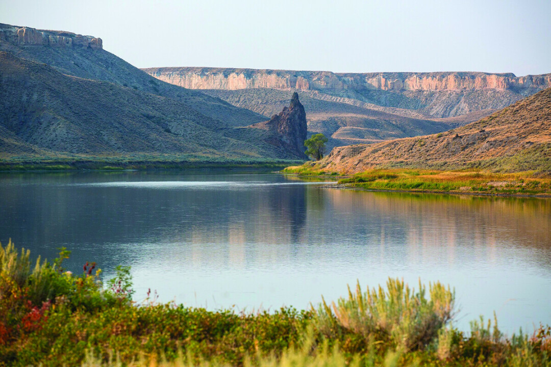
Considering all this, it seems a miracle that one of the best features of the river has survived as long as it has—the Missouri River Breaks, a stretch that meanders more than 150 miles from Ryan Island, near the upper (or western) end of Fort Peck Reservoir, to Fort Benton. After considerable study and debate, the Upper Missouri River Breaks National Monument was created by proclamation on January 17, 2001, encompassing 495,502 acres (2,005.23 km2), a fitting monument to the memory of Lewis and Clark. The adjacent Missouri River was designated an Upper Missouri Wild and Scenic River on October 13, 1976, after a dozen years of study and debate. The concerted endeavors of many Montanans, and others, assured preservation of the last free-flowing portion of the Missouri River.
The Missouri River Breaks represents one of the last remaining significant and essentially undisturbed segments of the longest river in Montana, and certainly one of the most important waterways in the world. On these points alone, its national significance could probably stand, but it has additional significant attributes. The Missouri, and specifically this section of the Missouri, has notable associations with the Lewis and Clark Expedition, and with subsequent historical events concerned with westward expansion and development of this nation—the fur trade, the gold rush, Indian and military affairs, river navigation, and the colorful era of the river steamboat.
And there’s much more. This stretch of the Missouri contains what is probably the most striking scenery of its 2,500-mile course, scenery that elicited glowing descriptions by Lewis and Clark, and was captured on canvas by the brush of the Swiss artist Karl Bodmer. As aptly put by the late historian, Stephen Ambrose: “As for the White Cliffs themselves, Lewis’s description is one of the classics of American travel literature.” Geologically, it tells a fascinating story, including the epic of its disarranged drainage and the cutting of a new river course because of continental glaciation. Archaeologically, the area possesses a large number of sites representing the aboriginal culture of the Plains Native Americans. In terms of wildlife, a diverse corridor of habitats provides for a wide array of plant and animal species. Aesthetically, it has the power to rekindle who-knows-what questions, memories and hopes. No computation can truly measure the incredible intricacies of the Missouri River Breaks.
Visitors who lack knowledge and expertise of the area’s diverse ecosystem and colorful history can still capture in their memories the richness and beauty of a twisting ribbon of water that runs boldly through, as Lewis would acknowledge, “a most romantic,” piece of country that lifts in great swells to the open horizons. It’s a place where one can readily picture Montana cowboy artist, Charlie Russell, standing atop a towering Eagle sandstone formation at Eagle Creek, facing the Missouri with arms fully outstretched, and pointing with his artist’s brush at the Missouri, saying, “All of this vibrant wonderland, from rim to rim, horizon to horizon, is for you and future generations to enjoy.”
One has to float the river to truly experience what the Breaks has to offer. By doing so, impressions do not arrive secondhand through the medium of words. Instead, the river speaks, using words from long ago—as if it were carrying you through a time warp in which past and present are joined. During your float, a Zen-like awareness heightens your senses with each passing day, and an unmistakable calmness surfaces with the passage of time and solitude. And then, only then, can you fully comprehend that the Missouri is more than moving water, more than a source of energy. A person can lose oneself here, both figuratively and literally.
Some mystic quality of the Breaks country permits one to enter a fourth dimension, a space too complex for human faculties to explain or understand. For example, a small wooded grove rests at the mouth of Arrow Creek, a short distance upstream from the mouth of the Judith River. On the opposite (north) side of the Missouri, Lewis and Clark pitched their May 29, 1805 camp. At the edge of the wooded grove is an old, deformed cottonwood, so designed by wind and decay to serve perfectly as a rest for one’s back. To sit in such a location after the sun dips below the galleries of wind-sculptured rock formations is an adventure in ecstasy. The mind and ear wander at will under the noises of the night without hindrance from outside attractions. In this setting, one can sense how it was 214 years ago when, for some unknown reason, a bull buffalo forded the river during the night and charged through the explorers’ sleeping camp. If you listen closely enough, you can just about hear the startled call of the night sentry, the frantic barking of Seaman, Lewis’ large Newfoundland dog, and the noisy uproar and clamor as the explorers awakened from deep slumber. In such a setting, one can let the mind further roam. Between the whisper of the wind and the rustle of cottonwood leaves, you might hear what sounds like a note from expedition member Cruzatte’s lively fiddle, but it will be nothing more, of course, than the aerial courtship of a common nighthawk thrusting his wings forward in a braking slowness as he pulls out of the dive, producing a deep, hollow vroom.
| Tweet |