Top 10 Hikes Around Bozeman
Steve McGann | Wednesday May. 1st, 2024
Someone once said; “You had better keep moving, something might be gaining on you.” They did not elaborate, but this is true. The something is The Mummy. This is a character from a series of movies, the first filmed in 1932 and the most recent in 2019. I watched the original on the Saturday Night Creature Feature when I was a kid. This caused some sleepless nights, but later some rational thought gave me peace of mind.
The Mummy, who has one arm bound to his chest and moves with one leg dragging, is after us, all of us. But to catch us, he has to first go everywhere we have gone and, while we may drive in a car or fly in a plane, The Mummy must walk. And he is slow. Yet he never stops or rests or sleeps. He is always moving—while we may be sleeping, watching TV, or are simply stationary. And since The Mummy is rarely seen, we do not know how far back he may be. So it is always good to keep moving. Running, walking, dancing, riding. Hiking is an especially great way to get moving in our area. There are a lot of great trails around Bozeman. Here are ten.
M Trail
This is Bozeman’s premier trail, and for good reasons. It is close to town, has varied terrain and, at the top, provides an amazing view of the city and the Gallatin Valley rolling away to the west. The only drawback is the size of the parking lot, but the Drinking Horse lot just across the road is much larger, and there is a convenient tunnel for walking under the highway. There are three trails to the M, all beginning in the same place. Generally, they are referred to as the steep way, the regular way, and the long way. The M is usually crowded, but well worth it. The angle of the mountain facing southwest means that snow melts there first. In the fall and spring it can provide a dry place to hike and train when most other trails in the area are still deep in snow or ice-covered. To avoid lots of other hikers, continue to the Ridge above the M or, on the long trail, keep going north on the National Scenic Foothills trail.
Drinking Horse
Right across the highway from the M is Drinking Horse Trail, a perfect alternative and complement to the former. Compared to other trails listed here, Drinking Horse is new, but it actually opened in 2008. It is a bit shorter than the M, with a little less elevation, but provides a beautiful and varied 2.5 mile loop. Another busy one, but the parking lot is spacious and the views from the summit are of the Hyalites, the entrance to Bridger Canyon, and the Ridge above the M. The top is spacious, but feels like a genuine summit. Look for raptors above once you have reached it.
Sourdough
Bozeman Creek has cut a narrow canyon down from the mountain south of town, and there is a road along the creek. The good news for hikers, bikers, skiers, dog walkers, and stroller pushers, is that the road is closed to motorized vehicles and open to everyone else. The road makes for a wide trail, needed since this is another busy route. The first five miles follow the creek and gently gain elevation. After the bridge, there are options. One is another five miles to Mystic Lake, another is to drop over into Hyalite via Moser Creek Road.
New World Gulch
Another trail that ultimately leads to Mystic Lake south of town is New World Gulch, accessed from Bear Canyon. This trail is just as close to town, though used much less. It is over five miles to the lake, but it is possible to cut up the slopes in a big meadow about two miles in and bushwhack to the summit of Mt. Ellis. The whole trail alternates between these spacious meadows and a tall fir forest.
Chestnut Mountain
Farther east, just off the Interstate 90 exit for Trail Creek is a parking area for Chestnut Mountain. This trail is known for mountain biking but provides a great hike, along with access to the Frog Mountain rock climbing area. The first section gains most of the elevation but once a hiker tops the ridge, the views east to the Absarokas are amazing. Try this hike in early to midsummer, when the wildflowers are in bloom. The summit is an easy knob a few miles along the mostly level ridgeline.
Palisade Falls
This list would not be complete without a couple of hikes in Hyalite Canyon, and Palisade Falls is a classic. Once you’ve reached the reservoir, take the road across the dam and drive past the campground to the fork. Take the east fork road to the Palisade Falls lot. The hike is fairly short, with a wide, paved path, but it is steep. The payoff is a delightful waterfall coming down through vertical volcanic dikes.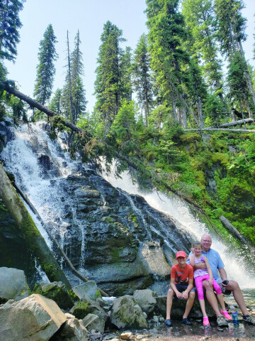
Grotto Falls
The approach road to Grotto Falls begins at the same fork as the one for Palisade Falls, but this time, take a right turn toward the Hyalite Lake trailhead. The trail extends to Hyalite Lake after 5.5 miles, and the top of Hyalite Peak after 7.5 miles. These are ambitious hikes but the trail to Grotto Falls is just one mile, and is handicap accessible. It is possible to push strollers or wheelchairs up to the falls viewpoint. The falls are beautiful anytime but are especially impressive in early summer. The pool at the base has a tiny beach, and dipping a hatful of frigid water to soak your hot head is bracing.
Middle Cottonwood
One of my gripes is that all too common names are used all too often. There are two Cottonwood hikes on this list. Both have cottonwood trees along creeks! This first is in the Bridgers. The turnoff is a few miles north of town, on Springhill Road. From the trailhead, the route parallels the creek for a mile or so in a narrow canyon. Just past where the Bridger Foothills trail intersects from the south, this trail leads to a broad bench with a dramatic view of the ridge. From there, it winds up through grassy meadows to a tiny saddle high on Saddle Peak. Summer flowers abound, then golden fall grasses take over.
South Cottonwood
The other trail of the same name is south of town. So, South Cottonwood. Access is south and then west on 19th Ave to Cottonwood and on to Cottonwood Canyon road. The hike heads off generally southeast through a wider, though more forested canyon. The trail crosses the creek several times on bridges and at shallow fords. Eventually, it hooks up with the History Rock trail and the Mt. Blackmore trail in Hyalite.
Kirk Hills
This is a little gem of a trail located at the bend of 19th Street south of town, as it heads west. The parking lot is just on the bend to the south of the road. This trail runs through fairly dense forest and at times is rather steep. It crests a large hill, which provides views back toward town and off into other adjacent canyons. There are a couple of loops to give variety, and like a lot of these south of Bozeman trails, there are link paths that lead on to Hyalite, or even Sourdough drainage.
If you are new to hiking, remember that it is not walking. Hiking does not have the uninterrupted flow of walking. It is intermittent and requires more concentration. Some people do not care to gaze at their feet, but it is necessary, especially at first. For a view, stop. This article provides general locations and descriptions; mileage and elevation are readily available online with AllTrails and other apps. Pay attention to the elevation numbers. Kirk Hills and Drinking Horse are relatively short hikes, but steep. And going up, though strenuous, is easier than coming down. The Cottonwood trails, Grotto Falls, and Sourdough are much more gradual. Work your way up to the steeps.
These hikes are in the top ten for a reason—they are close to or in town, and are very popular. They can be crowded. If the joys of solitude and contemplation are important to you, there are other locations, other trails to explore. That said, even these ten can be hiked alone or with a companion or two by being creative with weather, time of day, and distance.
Just kidding about the Mummy, mentioned for motivational purposes only. Still... you never know. Our time is finite, and we are mobile beings. And our time spent in motion will make our rest feel earned and, well, restful.
| Tweet |