Lost Dakota: Gallatin County, Montana
Steve McGann | Monday Apr. 1st, 2024
At the southern tip of Gallatin County, there is a plot of land of eleven square miles, or about 7000 acres. The eastern border is the 111th meridian west; the northern is the 44 degree, 30-minute parallel north; the southern and western border is the Continental Divide. The area is adjacent to Idaho and Wyoming. Part of it is in Yellowstone Park; the rest is in the Gallatin National Forest. In the various land shuffles of the 1860s this little slice of land was overlooked. It is called Lost Dakota.
During that time, most of the Rocky Mountain West was uninhabited. Territories were created when enough people settled in a place for government to be desirable. This occurred mainly where there were gold strikes, or sufficient numbers of people beginning agricultural activities. Dakota was formed in 1861, Idaho in 1863, Montana in 1864, and Wyoming in 1868. The boundaries were fluid, and often altered. But after 1868 these northern tier states existed in the forms that would eventually be admitted to the Union as states.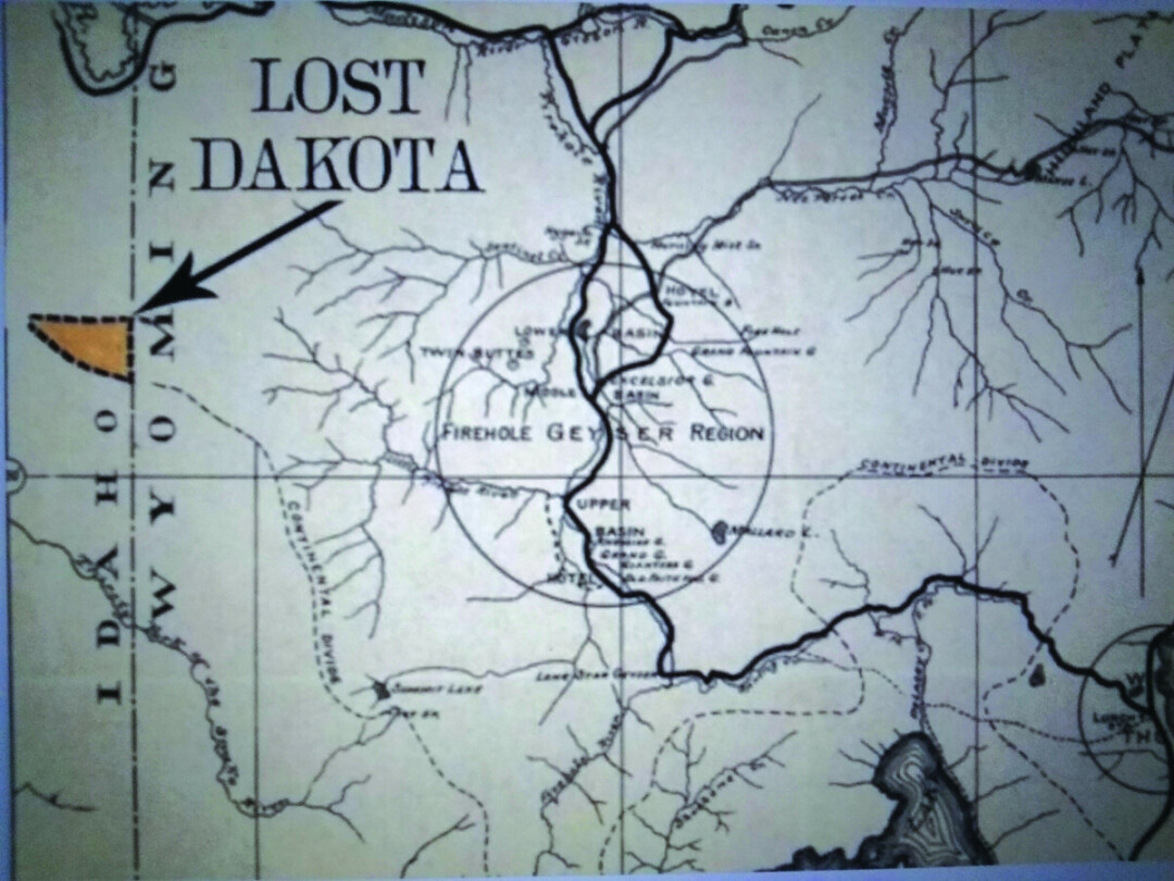
A glance at any U.S. map shows that most of the state borders in the west are comprised of straight lines. These were, of course, decided in Washington, D.C., far from the physical reality of the land. In the case of Montana, Idaho, and Wyoming, the baseline was the meridian of the D.C. Naval Observatory. The 34th meridian west from there, where it intersects with the Continental Divide, is the tripoint boundary of the three states. With this as a landmark, the rest of the margins were calculated. In theory.
The Organic Act of the Territory of Montana 1864 states that the southern boundary of Montana is the 45th parallel until it intersects with the 34th degree of longitude west, where it follows this line south to the parallel of 44 degrees, 30- minutes, then west to the Continental Divide. This ignored the previously decided tripoint boundary of Idaho, Wyoming and Montana which is located at 44 degrees, 23-minutes north. So, seven minutes of north-south distance were ignored, about eight miles. There was a chance when the Wyoming Territory was organized in 1868 to remedy this, but it was not noticed. Technically, the last official home for this parcel was in the Dakota Territory.
In 1872, the first national park in the world was declared. Yellowstone National Park had local boundaries that placed it mostly in Wyoming, but a bit into Montana and Idaho. In that process, a part of Lost Dakota was sort of found when it was included in the rectangle of the Park—but no one noticed that fact, either. Finally, in 1873 the discrepancy was rectified and Montana—specifically, Gallatin County—was awarded the lost sliver of wilderness. Thus, all was good with the bureaucrats, mapmakers, and politicians. Lost Dakota as a territorial entity existed for five years. As a physical place, it has always been right where it is. Lost Dakota contains no people, no structures, no roads, probably not even any trails. It is located south of West Yellowstone. No one goes there, which meant that I needed to. And a road trip to West Yellowstone is not a long one. In addition, West has its own attractions.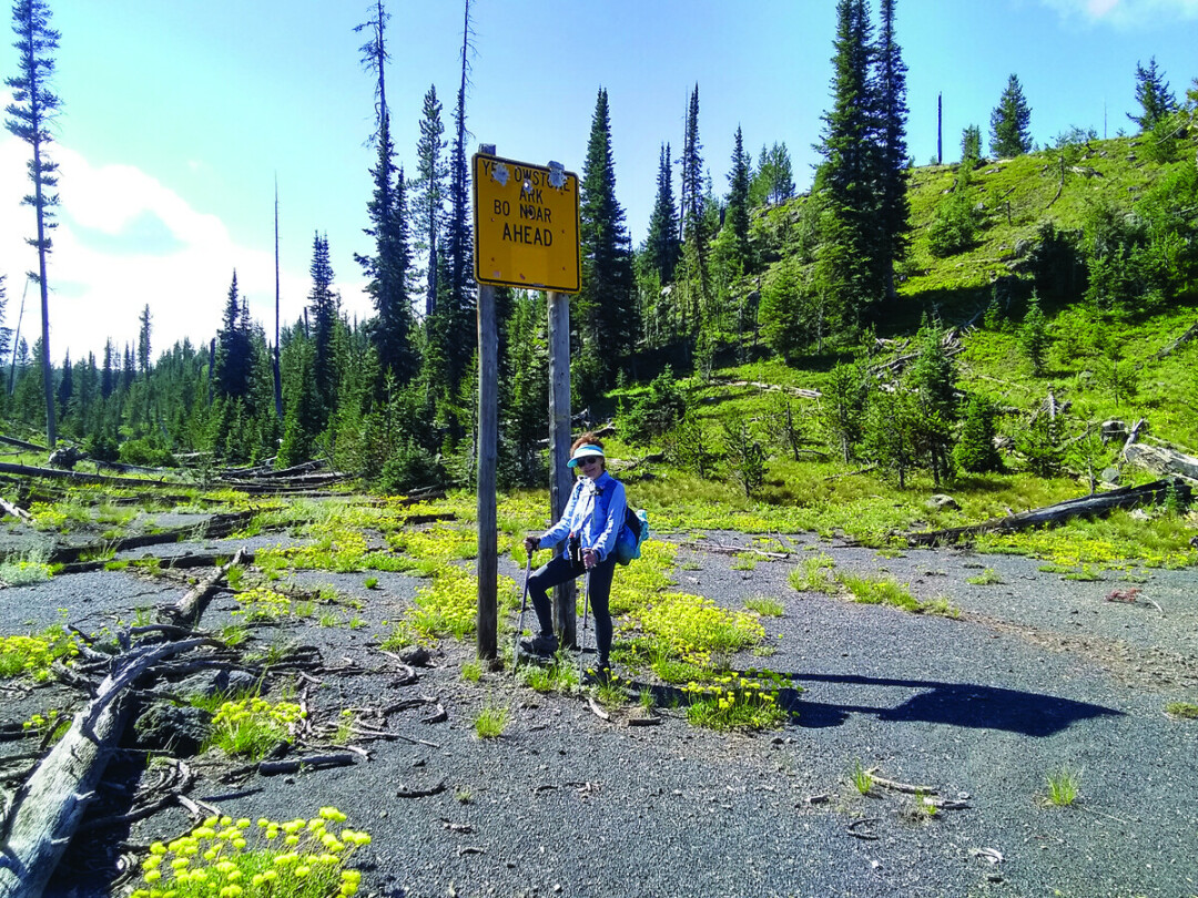
I made a few preparations and explained to my wife Ruth where I was going and what it was about. She said; “Sounds fun, I would like to go.” That was wonderful; a trip together would be great, not to mention having an adult along. I would be less likely to charge off with a pen and notebook and forget incidentals, such as food. We outfitted our pickup camper and headed south through Gallatin Canyon.
West Yellowstone is a great little town, perfect for its purpose as a gateway to Yellowstone. All its attractions are intended to build anticipation for the Park and to provide some last bits of civilization, some of them tasty. We stopped at two bakeries before we secured the perfect provisions for breakfast the next day. Then we opted for gyros on pita bread, saving the Mexican food truck for a return trip. West was August-busy, but after we located Forest Service Rd 1700 we saw no one for thirteen fairly rough miles. As expected, we encountered a locked gate and set up camp in the woods. It was fairly late in the afternoon, but we decided to take a hike behind the gate to get oriented for the following day, and calibrate my various maps and GPS devices.
Forest Service Rd 1700 continued, open only for snowmobiles in winter, and just for hikers in August. I estimated that the northern boundary of Lost Dakota was between two and three miles to the south. It looked like a good bit of the distance could be covered on this road. Another approach would be to drive over Reas Pass farther west and intersect with the Continental Divide Trail, then hike back east and, where it seemed promising, bushwhack up to the divide and into Lost Dakota. That looked to be longer. The road was gently ascending through a lodgepole forest that merged into white bark pine and subalpine fir. The verge was covered with lupine wildflowers. It was a very pleasant, relaxing hike in the late afternoon sunshine. But something was off.
We were trying to get to 44 degrees, 30-minutes north but, though we walked quite a ways, my GPS read 44.53126. That would be 20 minutes of latitude, which would be much farther.
I puzzled over this anomaly while we strolled back to camp. I checked Earthmate, Steptracker, and Google Maps. The readings were the same. I needed to speak to my son, a civil engineer, but he was teaching a class in New Zealand. Finally, after a couple of hours in the lawn chair, I realized that the paper maps used the minutes and seconds of latitude, while the internet apps calculated in percentages. Forty-four degrees, 30-minutes and 44.5000 were the same reading. I charged everything up and turned in for the night.
In the morning we retraced our steps. We came to a bend in the road where it looped back north, away from our goal. We had walked two miles. I had feared that the bushwhacking would begin here, as the forest was pretty dense. But just at the loop, the road crossed a little flat and dry canyon. It led off in exactly the right direction. The canyon was around fifty yards wide and had some deadfall that was easily stepped over or strolled around. The ground was carpeted with wildflowers and wild grasses. It looked inviting.
We ambled along for fifteen minutes. In the near distance, a large dead tree stood in the middle of the canyon. It was forty feet high, bleached by sun and snow and wind. I laughed and commented that maybe that was the boundary. When I was a couple of feet past the tree, I pulled out my phone and took a reading: 44.49995. We had passed into the piece of land called Lost Dakota. The tree was within a foot or two of the boundary—close enough for government purposes (pun intended).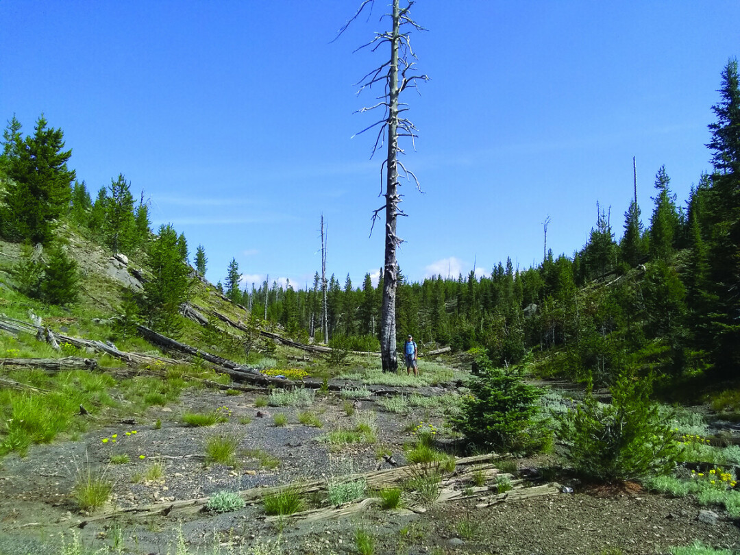
We sat on a nearby log for a water and snack break. We were just within an area with significant lines. The Yellowstone Park boundary was hundreds of yards to our east. The Continental Divide was hundreds of yards to our southwest. We could get up and walk back across the parallel of latitude we had searched for. With the edges of things all around, I thought it should feel different than sitting on a log in a quiet meadow. It didn’t. The place felt like what it was, part of a vast area of wild land.
“Be it enacted by the Senate and House of Representatives of the United States of America in Congress assembled, That all that portion of Dakota Territory lying west of the one hundred eleventh meridian of longitude which, by an erroneous definition of the boundaries of said Territory by a former act of Congress, remains detached and distant from Dakota proper some two hundred miles, be, and the same hereby, attached to the adjoining territory of Montana.” Approved February 17, 1873.
The territorial evolution of Montana from 1670 until statehood in 1889 lists two dozen separate classifications from something called Rupert’s Land to Louisiana to several US Territories, predating statehood. Of course, nothing about the land itself ever changed, just the names and dates in various government ledgers. Lost Dakota, which only existed on paper and only for about five years, fits into this category. It turns out to be a beautiful place and well worth the trip, but no different than all the wilderness around it, despite its official history.
We had a pleasant walk back to the truck and somehow felt we had accomplished more than a simple morning stroll in the woods.
| Tweet |