Driving the Beartooth Highway
Thursday Aug. 1st, 2013
Bozeman has a beautiful backyard. The Gallatin Range fences in forests and alpine meadows perfect for hiking, biking, camping, and fishing. Recreational opportunities abound in our backyard, but it is Bozeman’s back forty, Yellowstone National Park, that draws visitors from all over the world. Yellowstone is so rich with wildlife, history, and geological rarities that visiting should be on everyone’s bucket list.
Three different routes lead from Bozeman to Yellowstone, and deciding which to take might be the most difficult part of planning a trip to the Park. Chasing the Gallatin River along Highway 191 is a picturesque drive to Yellowstone’s West Entrance. U.S. Highway 89 from Livingston to the Park’s North Entrance is another beautiful option—they call it Paradise Valley for a reason. However, the path to the Park that is farthest away provides perhaps the most interesting and exciting drive to Yellowstone.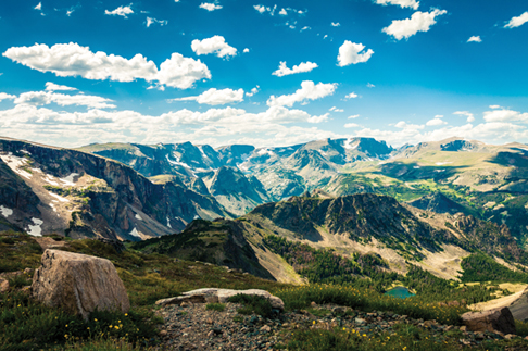
It takes a little over two hours to reach the Beartooth Highway from Bozeman, but it is two hours well spent. The Beartooth Highway (U.S. Highway 212) runs 68 miles from Red Lodge to the Northeast Entrance to Yellowstone. Reaching an altitude of 10,947 feet, the road is the highest in the Northern Rockies. I really do feel like I am driving on top of the world as I travel over the barren alpine tundra. Yet, 20 peaks towering over 12,000 feet tall remind me that I’m not quite there. Montana’s highest mountain, Granite Peak, challenges visiting climbers to make its ascent. At the Beartooth’s highest elevation, terrain is so rugged that the only year-round residents are the marmots and pika.
Frigid winter conditions meant construction of the road could only take place during the summer months. The Beartooth Highway officially opened in June of 1936, after four years of construction by three different companies each responsible for a segment of the highway. By this time, Yellowstone had been a National Park for 70 years and the invention of the automobile was making it a popular tourist destination. Red Lodge and Cooke City were well-established mining towns and the need for a road to move people and materials became clear. In 2002, the Beartooth Highway received the National Scenic Byway’s most prestigious distinction of All-American Road. Garnering this designation required a community effort, just as maintaining the road does today. The Beartooth is considered an orphan road because no particular state or federal agency claims ownership or responsibility. Instead, it is maintained by the cooperative efforts of several agencies.
Long Lake Bridge was replaced this summer, and construction efforts continue on the bridge and a small section of surrounding road. The construction has caused short delays for travelers and that portion of road is occasionally closed at night, but as summer winds down, so does construction. Current updates can be found online at www.beartoothhighway.com.
The Beartooth Highway remains a marvel of engineering. Hairpin switchbacks go on for over seven miles as you climb 4,000 feet from Rock Creek Canyon outside of Red Lodge to the Beartooth Pass. If I’m not driving this part of the road, I am clinging to my seat trying not to look down. Thankfully, there is plenty to see when I keep my eyes up and look around. This intense ascent transports me from lush creekbed to barren tundra in a matter ofminutes. At the bottom, the trees grow tall and strong like sentinels of the forest, but at the top of the pass trees grow crooked and stunted like ancient beings braced against the wind.
The actual “bear tooth” is a spire that rises from the Beartooth Plateau and is visible from the West Summit pullout. The Crow named the spire Na Piet Say, which means “the bear’s tooth.” Glaciers carved the tooth, like the rest of the peaks along the highway, over one million years ago. The area is rich with geological history; some of the oldest rocks on Earth exist here. Beneath Beartooth Butte, fossils that are 500 million years old have been found.
Beartooth Lake, just beneath the Butte, is a popular fishing spot. One of the area’s most beautiful waterfalls tumbles from the southern end of the lake. The Beartooth Highway begins and ends in Montana, but much of it traverses Wyoming. People planning to fish the Clark’s Fork of the Yellowstone River or one of the thousands of lakes in the area should pay attention to their location and make sure they have the proper fishing licenses; Wyoming, Montana, and Yellowstone National Park all have separate licenses.
Fishing isn’t the only recreational opportunity along the highway. In fact, if this is your chosen route to Yellowstone, you might want to schedule a few days into your trip just for getting there. The Beartooth Highway is surrounded by one million acres of wilderness—hiking, biking, and backpacking opportunities are endless in the summer and snowmobiling and skiing are popular in the winter. (Actually, skiing is pretty popular in the summer, too, as snow tends to linger at the highest elevations.) Tours of all kinds, from an afternoon of fishing to multiple nights in the backcountry are arranged out of the three towns that anchor the route. Cooke City and Red Lodge flank the Beartooth Highway, and Cody, Wyoming is just over 40 miles down the Chief Joseph Scenic Byway, which intersects the Beartooth between Cooke City and Beartooth Pass.
There are 13 campgrounds along the Highway, so it is easy to spend some significant time up there. The Top of the World Store is the only store offering food and fuel, so travel prepared. The Beartooth Highway is bear country so it is also important to follow all regulations related to food storage and bear safety. Bring a coat because it can get cold on top of the world, especially at night. And, it would be a crime to climb into the tent too early because on the Beartooth, you are about as close to the stars as you’re ever going to get.
Sarah Cairoli can be reached at scairoli30@hotmail.com.
| Tweet |